High-altitude cryospheric failures present an escalating systemic risk to downstream infrastructure across the Hindu Kush Himalaya region. When an estimated two million square feet of glacial ice shears away from a mountain wall, it converts potential energy into kinetic devastation within minutes. The resulting disaster along the Nepal-Tibet border, which left hundreds dead and over fourteen hundred missing, is not merely an isolated weather anomaly. It is the physical manifestation of accelerated thermal erosion acting on fragile geologic structures. Deconstructing the mechanics of this event requires analyzing the primary failure vector, the hydrodynamic properties of debris flows, and the structural vulnerabilities inherent in cross-border disaster response.
The initial trigger mechanism operates through sub-glacial thermal dynamics. As ambient temperatures rise faster than the global average at high elevations, permafrost degrades and internal meltwater channels expand. This liquid water acts as a high-pressure lubricant at the bedrock-ice interface, reducing frictional resistance until structural integrity fails entirely. The subsequent collapse generates a seismic signature often misidentified initially as tectonic activity due to the immense mass displacement. When the ice mass drops thousands of feet to the valley floor, it pulverizes instantly, mixing with accumulated surface water and moraine material to form a high-density hyper-concentrated flow.
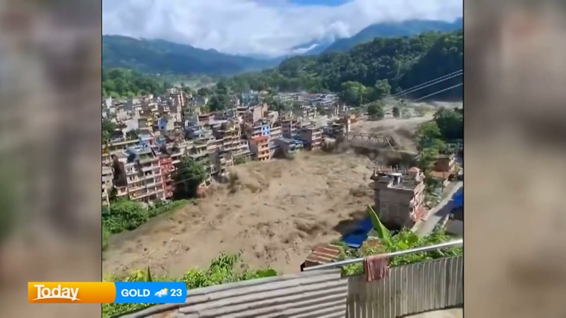
Fluid dynamics dictate the destructive capacity of the downstream surge. Unlike standard water floods, a glacial debris flow behaves more like liquid concrete, possessing a high specific gravity that increases its momentum and destructive force exponentially. River channels cannot contain the sudden volumetric spike, causing the torrent to spill across valley floors at velocities that preclude effective evacuation without an automated, seconds-level early warning architecture. Bridges, hydroelectric installations, and multi-story concrete structures face structural overload almost immediately upon impact because the dynamic pressure of the moving mass exceeds standard engineering safety margins for fluvial floods.
Secondary hazards compound the initial crisis through the formation of barrier lakes. When massive volumes of rock, ice, and mud choke narrow river gorges, they create temporary natural dams with no engineered spillways. These impoundments fill rapidly from upstream runoff and meltwater, creating an escalating hydrostatic load against unstable debris matrices. Satellite monitoring and hydrologic modeling indicate that millions of cubic meters of water pooled behind these blockages present a continuous secondary breach threat to rescue operations downstream. Emergency managers must treat the clearance or controlled breaching of these temporary natural dams as a primary operational priority to prevent compounding losses.
Human geography and economic activity intersecting with high-risk corridors amplify casualty counts. Himalayan river valleys serve as historical trade routes, modern highway alignments, and pilgrimage paths, concentrating temporary populations alongside permanent settlements. Foreign trekkers, seasonal laborers, and local residents occupy narrow floodplains where escape vectors are limited vertically and horizontally by steep canyon walls. Search and rescue logistics face severe operational bottlenecks when primary access roads are severed by kilometers of missing infrastructure, forcing reliance on rotary-wing aircraft that remain grounded during adverse weather windows.
Mitigating future high-altitude cryospheric disasters necessitates a shift from reactive disaster response to predictive risk engineering. Governments across the region must integrate real-time satellite radar interferometry with automated acoustic sensors placed at high-risk glacial lakes and steep ice walls. Establishing synchronized cross-border data-sharing protocols between upstream and downstream nations remains essential for securing the lead time required to move populations out of narrow valley floors before a debris wave arrives.