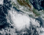
Meteorology has long treated extreme weather as an anomaly, an inconvenient disruption to an otherwise predictable planetary rhythm. When Hurricane Polo surged off the coast of Mexico, fueled by the thermal anomaly known as El Nino, forecasters scrambled to update their tracking models. But the storm itself is merely a symptom of a larger, more systemic breakdown in ocean-atmosphere dynamics.
The core mechanics driving a storm like Polo are rooted in an accumulation of upper-ocean heat. El Nino acts as a massive thermal battery, shifting warm water pools across the equatorial Pacific and altering atmospheric pressure systems thousands of miles away. When a hurricane moves over these supercharged waters, the traditional friction points that typically weaken a storm vanish.
Understanding the intensification of Hurricane Polo requires looking past the immediate wind speeds and storm surges. Decades of atmospheric data reveal a disturbing trend. The baseline temperature of the Eastern Pacific has risen steadily, providing an expansive breeding ground for rapid cyclogenesis. Storms are no longer just growing stronger; they are accelerating past the thresholds of standard warning timelines, catching coastal populations unprepared.
Emergency management protocols in Western Mexico were originally designed for storms that intensified over days, giving authorities ample time to coordinate evacuations. Polo shattered that paradigm. Systems capable of jumping from a tropical depression to a major hurricane in under twenty-four hours render conventional lead times obsolete. This speed mismatch represents a profound institutional vulnerability.
The Thermal Gradient Problem
At the heart of the crisis is an intensifying thermal gradient. As greenhouse gas emissions continue to trap excess heat within the biosphere, over ninety percent of that thermal energy is absorbed by the world's oceans. The Eastern Pacific off the Mexican coastline experiences this accumulation acutely.
When an El Nino phase overlaps with this background warming, the surface temperature anomalies create a vertical column of unstable air. Warm, moisture-laden air rises rapidly, condensing into towering convective cells that spin up cyclonic rotation with terrifying efficiency.
"We are looking at thermodynamic engines that operate on entirely different energy budgets than the storms we studied twenty years ago."
Satellite monitoring has improved dramatically, yet predictive modeling still struggles with rapid-intensification events. Current numerical weather prediction models often under-resolve the fine-scale ocean-atmosphere interactions occurring in the boundary layer. The computer simulations see the warmth, but they frequently miss the sudden micro-scale feedbacks that allow a hurricane to pull energy out of the water column at unprecedented rates.
Infrastructure Under Pressure
Coastal infrastructure along the Baja Peninsula and the mainland Mexican coast was engineered to withstand historical maximums, not the hyper-charged realities of modern storms. Sea walls built to handle once-in-a-century storm surges now find themselves tested with alarming regularity.
Drainage systems in burgeoning coastal cities cannot cope with the sheer volume of precipitation dumped by slow-moving or rapidly accelerating tropical systems. Flash floods routinely cut off transportation corridors, isolating communities and crippling emergency response efforts before the winds even peak.
The economic fallout extends far beyond immediate property damage. Tourism revenue, agricultural yields, and commercial fishing operations face recurring shocks that compound over time. Insurance markets are beginning to reprice risk along these vulnerable coastlines, signaling a looming financial crisis for property owners who may soon find coverage either unaffordable or entirely unavailable.
Adapting to a New Atmospheric Reality
Mitigating the threat posed by systems like Hurricane Polo demands a fundamental overhaul of how coastal regions approach disaster preparedness. Early warning systems must transition from static advisory bulletins to dynamic, real-time risk communication networks that can reach mobile populations instantly.
Furthermore, zoning laws must evolve to reflect updated flood maps and storm surge projections. Rebuilding in the exact same footprint after a disaster is an exercise in repeating history at taxpayer expense. Managed retreat from highly vulnerable shorelines, while politically contentious, remains the only viable long-term strategy for high-risk zones.
The atmosphere does not negotiate, and it does not wait for bureaucratic consensus. Hurricane Polo served as a stark reminder that the historical baseline for weather extremes is gone. What remains is a volatile frontier where preparation must match the ferocity of the changing climate.