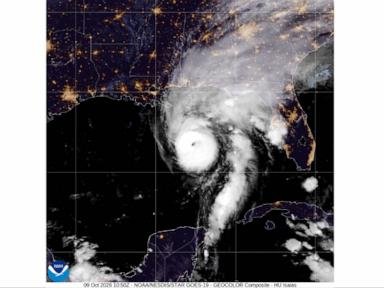
Severe weather communication suffers from a systemic translation failure between meteorological science and public perception. When a tropical system approaches land, the communication apparatus relies on shorthand nomenclature—spaghetti models, rapid intensification, storm surge—that flattens complex atmospheric dynamics into sensationalized soundbites. This linguistic compression obscures the underlying physical mechanisms, leaving decision-makers and the public to interpret probabilistic noise as deterministic certainty. Mastering severe weather risk requires replacing vague terminology with rigorous conceptual frameworks. Analyzing a tropical cyclone demands decomposing its behavior into thermodynamic efficiency, boundary layer friction, and ensemble divergence.
The Structural Anatomy of Tropical Cyclones
A hurricane is not a discrete meteorological object but a self-sustaining thermodynamic engine operating within a fluid envelope. To understand its operational lifecycle, one must examine the conversion of heat energy into mechanical work. The Carnot cycle provides the foundational baseline for this analysis, where the ocean surface acts as the high-temperature reservoir and the upper troposphere serves as the low-temperature sink.
The fundamental fuel for this engine is enthalpy flux from the ocean surface, driven by the sea surface temperature threshold of twenty-six degrees Celsius. As air parcels travel inward toward the low-pressure center, they absorb latent heat through moisture evaporation. The pressure gradient force accelerates these parcels inward, constrained by the Coriolis effect, which imparts rotational momentum. Upon reaching the eyewall, this moisture-laden air ascends violently, releasing latent heat of condensation. This thermal expansion maintains the warm core aloft, preserving the horizontal pressure gradient that sustains the system.
Frictional dissipation at the boundary layer acts as the primary brake on this system. In the lowest kilometer of the atmosphere, surface drag disrupts gradient wind balance, forcing air vectors to cross isobars directly into the center. This inflow boundary layer convergence feeds the eyewall updrafts. If surface friction increases abruptly—such as during landfall—the inflow angle alters, boundary layer convergence collapses, and the mechanical energy generation fails to outpace frictional loss. The storm decays not because it runs out of warm water, but because the mechanical feedback loop is severed.
Deconstructing Ensemble Forecasting and Spaghetti Models
Public consumers frequently encounter spaghetti models on television screens or social media feeds: a chaotic web of colored lines projecting a cyclone trajectory across a basin. Misinterpreting this output as a set of competing predictions leads to catastrophic evacuation planning errors. A single deterministic forecast run is a single calculation derived from initial state conditions. Because the atmosphere is a chaotic, non-linear fluid system governed by Navier-Stokes equations, infinitesimal errors in initial observations compound exponentially over time, known as the butterfly effect.
Numerical weather prediction addresses this inherent uncertainty through ensemble forecasting. Instead of running a single model, meteorologists run dozens of perturbed simulations simultaneously, varying initial conditions and physical parameterizations slightly. The resulting cluster of trajectories is the ensemble suite, visually represented as the spaghetti model spaghetti plot.
The analytical value of a spaghetti model does not lie in tracing any single colored line. Every individual line is equally plausible physically, but none possess higher individual probability than the others. The analytical signal is found in spatial density and divergence.
When ensemble members cluster tightly along a narrow corridor, the atmospheric steering flow is governed by dominant, well-resolved synoptic features such as a deep subtropical high-pressure ridge. Under this condition, trajectory predictability is high. When the ensemble members fan out across a wide geographic arc, it indicates weak steering currents and high sensitivity to small-scale perturbations.
Navigating this output requires shifting from binary point forecasts to probabilistic risk assessment. Emergency managers do not ask where the storm will hit; they calculate the cumulative probability distribution function across spatial coordinates to determine threshold crossing times for gale-force winds.
The Kinematics of Rapid Intensification
Rapid intensification represents the most acute forecasting failure mode in operational meteorology. Defined formally by the National Hurricane Center as an increase in maximum sustained winds of at least thirty knots within a twenty-four-hour period, this phenomenon compresses days of normal storm evolution into hours. Analyzing rapid intensification requires examining the decoupling of negative environmental factors and the optimization of inner-core thermodynamics.
The primary inhibitory forces preventing rapid intensification are environmental vertical wind shear and dry air entrainment. Vertical wind shear—the change in wind speed and direction with height—tilts the vortex axis, displacing the warm core aloft from the low-level circulation center. This ventilation effect strips the latent heat release away from the core, choking the engine. Dry air entrainment into the mid-level troposphere causes evaporative cooling of downdrafts, which stabilizes the boundary layer and cuts off the inflow of high-entropy air.
Rapid intensification occurs when these inhibitory vectors are neutralized. This transition is governed by three specific operational parameters:
- Upper-level outflow optimization, where an anticyclone aloft establishes a vent that exhausts mass away from the storm center at a rate matching the low-level convergence.
- Inner-core axisymmetric organization, characterized by the contraction of the radius of maximum winds, which concentrates angular momentum via conservation principles.
- Microphysical efficiency, where cloud-resolving processes maximize precipitation fallout within the eyewall, reinforcing local diabatic heating.
When these conditions align, the system experiences a positive feedback loop: lower central pressure accelerates inflow, which increases surface enthalpy flux, which intensifies latent heat release, which further drops the central pressure. Because this process operates on non-linear acceleration curves, conventional linear extrapolation models fail entirely to predict the inflection point.
Hydrodynamic Mechanics of Storm Surge
Of all tropical cyclone hazards, storm surge accounts for the highest percentage of direct water-related fatalities, yet it remains persistently misunderstood as a simple moving wall of water or a giant tide. Storm surge is a complex hydrodynamic response driven by surface wind stress and atmospheric pressure reduction over a shallow marine shelf.
The two primary physical drivers of storm surge are the inverse barometer effect and wind-driven surface stress. The inverse barometer effect is a direct hydrostatic response: lowered atmospheric pressure at the eye of the storm allows the ocean surface to bulge upward. For every millibar drop in central pressure, the local sea level rises by approximately one centimeter. While significant, this pressure component accounts for only a minor fraction of the total destructive water height in major hurricanes.
The dominant driver is wind stress. As sustained hurricane-force winds blow across the ocean surface, frictional drag transfers momentum to the water column. In deep ocean basins, this momentum simply generates surface waves and deep circulation. However, as the storm approaches a shallow continental shelf, the water has nowhere to go downward. The horizontal velocity of the water piles up against the coastline, creating an extreme pressure gradient force directed offshore.
The bathymetry of the coastal shelf dictates the severity of the surge response. A gently sloping, wide continental shelf—such as the Gulf Coast of the United States—amplifies storm surge dramatically because the shallow bottom traps water and prevents vertical mixing. Conversely, a steep drop-off near the coast allows water to recirculate into deeper depths, mitigating the peak height.
Local coastal geometry, including bays, inlets, and river mouths, acts as a hydrodynamic funnel, further compressing the water volume and raising the surge height well above predicted astronomical tide levels.
Strategic Operational Protocol for Severe Weather Risk
Effective mitigation of tropical cyclone exposure requires abandoning static response plans in favor of dynamic threshold monitoring. Organizations and municipal authorities must construct decision matrices anchored to objective meteorological triggers rather than subjective advisory categories.
The primary operational threshold is the onset of sustained tropical-storm-force winds, which marks the absolute deadline for completing vulnerable surface evacuations and infrastructure securement. Relying on the projected center track introduces a severe cognitive bias known as the cone of uncertainty fallacy, where planners ignore hazards outside the central line. The cone represents only the historical error of the track forecast; it says nothing about the physical spatial extent of damaging winds or storm surge, which frequently extend hundreds of miles beyond the boundary.
Transitioning from reactive crisis management to analytical preparedness demands integrating ensemble spread into logistics planning. Supply chains and operational continuity models must test against the worst-case outer envelope of ensemble trajectories rather than the deterministic mean path.
By treating weather forecasts as probabilistic distributions rather than definitive future states, decision-makers can deploy capital and resources efficiently across varying confidence intervals, insulating operations against the inherent chaos of atmospheric physics.