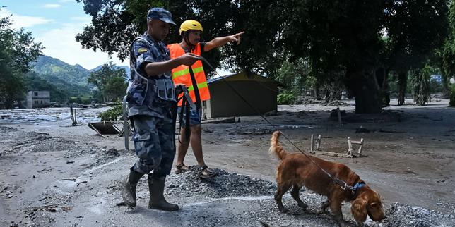
Water does not negotiate when it falls from the roof of the world. Heavy monsoon rains and rapid glacial melt have triggered catastrophic floods across Nepal and Tibet, leaving destruction in their wake and sparking urgent warnings from disaster management authorities. The immediate threat centers on vulnerable glacial lakes on the Tibetan plateau, where pressure mounts against fragile natural dams. If these barriers fail, an already devastated region faces a secondary deluge capable of wiping out downstream infrastructure, hydroelectric plants, and remote mountain communities.
The mechanics of glacial lake outburst floods are terrifyingly simple. As temperatures rise globally, glaciers retreat and leave behind massive basins filled with meltwater, held back only by loose rock, debris, and terminal moraines. These natural walls are fundamentally unstable. When an extreme weather event dumps unprecedented volumes of rain onto steep Himalayan slopes, the hydrostatic pressure inside these high-altitude lakes spikes dramatically. You might also find this related story useful: The Structural Cost of Alignment Bangladesh and the Mecca Pact Calculus.
The Anatomy of a High-Altitude Crisis
Understanding why these floods happen requires looking past the immediate weather reports. Monsoon downpours are becoming increasingly erratic across South Asia. Traditional precipitation patterns have broken down, replaced by concentrated cloudbursts that drop months of rain in a matter of hours. The soil on steep mountain faces cannot absorb moisture that quickly. Landslides tear through river valleys, choking waterways with mud and debris before sending massive torrents crashing downstream.
In Tibet, officials have monitored several high-risk glacial lakes where water levels have breached safety thresholds. When a moraine dam collapses, millions of cubic meters of water rush downward in minutes. This creates a wall of water, mud, and boulders that behaves like a moving concrete mixer. Bridges vanish, highways dissolve, and entire villages disappear before residents receive any meaningful warning. As extensively documented in recent coverage by Al Jazeera, the implications are notable.
Downstream in Nepal, the topography magnifies the danger. Narrow gorges funnel the floodwaters, increasing their velocity and destructive power. Communities situated along the Arun, Sun Koshi, and Tamoshi river basins live with constant anxiety during the peak monsoon months. Hydroelectric facilities, which represent critical economic investments for Nepal's energy independence, sit directly in the path of these potential torrents. Several projects have already suffered severe damage, highlighting a critical flaw in regional infrastructure planning.
Institutional Blind Spots and Cross-Border Gaps
Disaster response in the Himalayas is complicated by complex geopolitics. Weather systems do not respect international borders, but emergency communication protocols often stall at the frontier. Most high-altitude glacial lakes that threaten Nepal originate in the Tibet Autonomous Region of China. Real-time hydrological data sharing between Beijing and Kathmandu remains inconsistent, leaving Nepalese authorities reacting to downstream surges rather than anticipating upstream failures.
Early warning systems have improved over the last decade, funded by international development banks and climate adaptation funds. Sirens and automated river gauges now dot remote riverbanks. Yet technology alone cannot solve a geography crisis. Many sensors fail during extreme weather events when power lines snap and communication towers wash away. Maintenance in these brutal, high-altitude environments is punishingly difficult. Technicians often cannot reach damaged equipment until months after the monsoon season ends.
Local communities bear the heaviest burden of these institutional shortcomings. Mountain villagers know the signs of an impending flood, watching the color of the river change from clear blue to muddy gray as upstream landslides dump sediment into the water. However, traditional knowledge is losing its reliability as the climate changes. Floods now arrive faster, hit harder, and occur in months when rivers historically ran low and predictable.
Economic Fallout and Long-Term Vulnerability
The destruction extends far beyond immediate humanitarian needs. Tourism, the financial lifeline for countless families in the Himalayas, grinds to a halt when trekking routes wash out and airports close. Trekkers find themselves stranded in remote lodges, waiting for expensive helicopter evacuations that stretch local rescue capabilities to their absolute limits.
Rebuilding washed-out infrastructure drains national treasuries. Roads built into steep mountain faces cost millions of dollars and months of labor to construct, only to be washed away by a single night of torrential rain. International donors frequently step in with emergency aid, but long-term structural resilience requires billions in capital investment. Engineers must redesign bridges with higher clearances, relocate vulnerable settlements to higher ground, and reinforce riverbanks with heavy engineering works that blend into fragile mountain ecosystems.
The situation in Nepal and Tibet serves as a warning for other mountainous regions globally. As glacial retreat accelerates, the number of unstable lakes grows every year. Managing this risk demands unprecedented international cooperation, massive financial commitment, and an honest reckoning with the physical limits of building infrastructure in extreme environments. Until those investments materialize, the sound of rushing water during the monsoon will continue to terrorize the valleys below.