The Litani River is not just a body of water. For over a century, this 140-kilometer stretch of Lebanese blue gold has been the silent protagonist in a regional struggle that transcends modern borders. To understand why the Israeli military is currently operating in Southern Lebanon, one must look past the immediate headlines of rocket fire and tunnels. The strategic obsession with the Litani is rooted in a specific vision of survival that predates the 1948 establishment of the State of Israel. It is a story of hydraulic necessity meeting hardline geopolitics.
The primary reason for the enduring conflict over the Litani is the intersection of water security and military geography. For Israel, the river represents the "ideal" northern border—a natural moat that provides both a defensive barrier and a potential solution to the region’s chronic water scarcity. For Lebanon, the river is a sovereign lifeline, essential for the agriculture and power generation of its southern provinces. The current friction is the latest chapter in a long-standing effort to push hostile forces north of this specific line, a goal that has remained remarkably consistent across different Israeli administrations and military doctrines. You might also find this similar coverage interesting: Geopolitical Brinkmanship and the Mechanics of Digital Escalation in the Israel Pakistan Friction Point.
The Zionist Architects and the Hydraulic Dream
Long before the first tanks crossed the border, the "fathers of the nation" were obsessed with maps. In 1919, Chaim Weizmann, who would later become Israel’s first president, wrote to the British government insisting that the borders of the future Jewish state must include the lower reaches of the Litani. He argued that without these waters, the land could never be economically self-sufficient. This was not mere greed. It was a cold calculation.
The early Zionist leadership saw the Middle East through the lens of resource management. Men like David Ben-Gurion understood that a modern industrial state cannot survive on rainfall alone. They looked at the Litani—which flows entirely within Lebanon before making a sharp turn toward the Mediterranean—and saw a wasted resource. Their early proposals to the Paris Peace Conference sought a border that would bring the Litani’s bend under their control. They failed to secure that map, but the ambition never truly evaporated. It simply went underground, resurfacing every time the regional security architecture shifted. As reported in recent reports by The Guardian, the implications are worth noting.
The 1978 and 1982 Precedents
History does not repeat, but it often rhymes with the sound of artillery. In 1978, Israel launched Operation Litani. The objective was explicitly stated in the name. The goal was to clear PLO militants from the area south of the river to create a "security belt." This established the Litani as the definitive geopolitical benchmark. It was no longer just a water source; it became a military boundary.
The 1982 invasion took this logic even further. By reaching Beirut, Israel attempted to fundamentally rewrite the Lebanese political order. However, even as they eventually withdrew to a smaller "security zone" in the south, the shadow of the Litani remained. Rumors persisted for decades that Israel was secretly siphoning water from the river via underground tunnels. While hydro-engineers and UN observers have largely debunked these specific claims of theft, the fact that the rumors were so widely believed speaks to the river's symbolic power. The fear was not just about the water Lebanon was losing, but about the control Israel was gaining.
Hezbollah and the 1701 Deadlock
The current crisis centers on UN Security Council Resolution 1701, the document that ended the 2006 war. It mandates that no armed personnel, assets, or weapons other than those of the Lebanese government and UNIFIL should be deployed between the "Blue Line" (the border) and the Litani River.
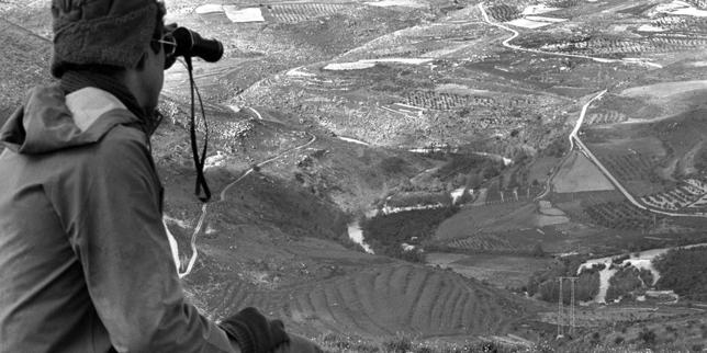
This resolution has been a dead letter for years. Hezbollah did not move north. Instead, they built a sophisticated "nature reserve" of bunkers and launch sites in the very valleys the UN was supposed to monitor. For Israel, the Litani represents the "red line" for security. If Hezbollah’s elite Radwan Forces are south of the river, the entire Galilee region is within range of an October 7-style ground incursion.
The military logic is simple. The terrain between the border and the Litani is rugged, characterized by deep wadis and high ridges. If an army controls the heights overlooking the river, it controls the movement of everything below it. This is why the Israeli Defense Forces (IDF) are currently focused on clearing these specific villages. They aren't just fighting a militia; they are trying to enforce a geography that hasn't existed in reality for nearly two decades.
The Economic Lifeblood of the South
South Lebanon is often portrayed as a battlefield, but it is also an agricultural engine. The Litani feeds the Qasmieh irrigation project, which is vital for the citrus and banana groves that line the coast. If Lebanon loses access to the river's lower basin—either through direct occupation or by it becoming a "no-man's land"—the economic impact would be catastrophic for a country already in the midst of a financial collapse.
The Litani also powers the Karaoun Dam and several hydroelectric plants. In a country where the national power grid provides only a few hours of electricity a day, these plants are more than just infrastructure. They are survival mechanisms. Any military movement toward the river threatens this fragile energy independence.
The Problem of Pollution and Neglect
Ironically, while the Litani is a strategic prize, it is also a dying river. Years of industrial runoff, sewage dumping, and government paralysis have turned parts of the upper Litani into a toxic sludge. The Karaoun Reservoir is frequently plagued by cyanobacteria blooms, making the water dangerous for humans and livestock alike.
- Industrial Waste: Hundreds of factories dump untreated chemicals into the basin.
- Agricultural Runoff: Pesticides and fertilizers from the Beqaa Valley drain into the flow.
- Infrastructure Failure: Many of the treatment plants built with international aid are non-functional due to the lack of fuel and maintenance.
This creates a bizarre paradox. A river that two nations have spent a century eyeing as a strategic necessity is being poisoned from within by the very country that owns it. If Israel were to ever "seize" the Litani, they would inherit an environmental disaster.
The Hard Truth of Buffer Zones
The concept of a "security buffer" up to the Litani is a seductive one for military planners, but history suggests it is a trap. In the 1990s, the "Security Zone" south of the river became a war of attrition that eventually broke the Israeli public's will to stay. A buffer zone requires boots on the ground, and those boots become targets for guerrilla warfare.
Technology has also changed the math. In 1978, pushing an enemy back 20 or 30 kilometers to the Litani meant their mortars couldn't reach your towns. In 2026, Hezbollah possesses missiles with ranges that span the entire length of Israel. Pushing them north of the Litani does not stop the long-range threat; it only removes the immediate threat of a ground raid.
This leads to a grim conclusion. The obsession with the Litani is as much about psychological security as it is about physical defense. For Israel, the river represents a clear, defensible line on a map that provides a sense of order in a chaotic region. For Lebanon, the river is the ultimate symbol of territorial integrity.
The Hydraulic War of the Future
Climate change is making the Litani more valuable, not less. As the Levant becomes hotter and drier, every cubic meter of fresh water becomes a strategic asset. The National Water Carrier of Israel already operates at near capacity. Lebanon’s water management is shambolic.
In this context, the Litani isn't just a boundary for soldiers; it’s a boundary for existence. The geopolitical "realism" that guided the Zionist founders in 1919 has evolved into a 21st-century survivalism. If you cannot control the water, you cannot control the future of your population. This is why the rhetoric from Israeli officials about "changing the reality on the ground" in the north is so persistent. They aren't just looking for a ceasefire. They are looking for a return to the map they’ve wanted since the British Mandate.
The reality on the ground is that the Litani is no longer just a river. It is a trench. It is a border that exists in the minds of generals even when it doesn't appear on the maps of the local farmers. Until there is a political solution that addresses both the security of the Galilee and the sovereignty of the Lebanese South, the water of the Litani will continue to be stained by the politics of its banks.
Military force can clear a river bank, but it cannot change the geography of a hundred-year-old grudge. The push toward the Litani is a gamble that a wider buffer will yield more safety, ignoring the fact that every previous attempt to hold this line has ended in a long, bloody stalemate.