When a slow-moving, training thunderstorm system dropped between 6 and 12 inches of precipitation over southeastern Missouri within a 24-hour window, it triggered what the National Weather Service characterized as a "once-in-a-thousand-years" meteorological event. The systemic shock focused heavily on Reynolds and Iron counties, forcing the tactical evacuation of more than 200 children and staff from Camp Taum Sauk and the emergency extraction of dozens of others from surrounding recreational zones along the Black River. This acute failure of regional infrastructure isolates a critical vulnerability: the delta between localized wilderness absorption capacity and municipal emergency response latency.
To evaluate the operational mechanics of this incident requires moving past sensational media narratives and into a rigorous, data-driven breakdown of structural hydrology, asset vulnerability, and multi-agency extraction logistics. Understanding how these systems interact determines the boundary between successful evacuation and structural catastrophe.
The Hydrological Forcing Function: High-Velocity Saturation
Wilderness zones in the Ozark Mountains operate under specific topographic constraints. When consecutive thunderstorms stall over a single geographic corridor—a phenomenon known as training—the soil profile reaches maximum saturation rapidly.
The cause-and-effect cascade of this specific flash flood model relies on three physical variables:
- Infiltration Excess Overland Flow: The rate of precipitation exceeded the soil's hydraulic conductivity. Once the topsoil reached absolute saturation, 100% of subsequent rainfall converted immediately into surface runoff.
- Volumetric Volatility: In the southeastern Missouri corridor, the Black River at Lesterville exhibited extreme volumetric acceleration, rising 8 feet within a single 60-minute window.
- Downstream Consequence compounding: This massive volume of water accumulated in narrow valley channels, driving the river toward an unprecedented projected crest of 28.73 feet near Annapolis, shattering the previous historical record set in 1993.
This rapid rate of rise invalidates traditional self-evacuation protocols. When water rises at multiple inches per minute, the time window required to assess, mobilize, and execute a vehicular evacuation shrinks faster than standard civilian decision-making cycles can accommodate.
Infrastructure Collapse and the Isolation Bottleneck
The primary structural bottleneck during this event was the immediate failure of secondary and tertiary transit infrastructure. Rural gravel roads and low-water crossings serve as the exclusive ingress and egress vectors for recreational camps like Camp Taum Sauk and the Bearcat Getaway campground.
The destruction of these transport links creates a distinct operational challenge: The Structural Isolation Penalty. This occurs when the physical environment strips an asset of its self-preservation options, shifting the entire burden of survival onto external rescue frameworks.
The Dynamics of Structural Yield
At the Bearcat Getaway campground, approximately 20 individuals sought refuge on the roof of a commercial campground building. The structural integrity of the facility failed under two simultaneous vectors of mechanical stress:
- Hydrodynamic Lateral Force: The constant velocity of high-density, debris-laden water moving beneath and against the foundation walls.
- Vertical Overload: The dead weight of dozens of individuals concentrated on a roof structure not engineered for localized live-load capacity under submersion conditions.
The resulting structural collapse pitched multiple occupants directly into high-velocity swift water, instantly escalating a passive stranding scenario into an active, life-threatening mass rescue operation. This highlights a fundamental flaw in emergency wilderness planning: treating standard civilian structures as valid high-ground assets during catastrophic hydrological events.
Multi-Agency Extraction Architecture and Resource Allocation
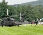
When infrastructure degradation prevents ground-based swift-water rescue teams from accessing a zone, the operation transitions to an airborne extraction model. In this instance, the activation of a state of emergency by the Missouri Governor triggered the deployment of the Army National Guard, utilizing UH-60 Black Hawk helicopters.
[Systemic Saturation] ➔ [Ground Transit Infrastructure Failure] ➔ [Total Asset Isolation] ➔ [Airborne Extraction Dependency]
The execution of an airborne mass evacuation of over 200 civilians from a constrained wilderness environment like Camp Taum Sauk follows a strict logistical dependency chain:
- Triage and Staging: Camp leadership successfully consolidated 168 teenagers and 60 adults into a single, identifiable high-ground perimeter. This internal coordination minimized the search phase of the military operation.
- Air-Shuttle Throughput: The operational velocity of an airlift is capped by cabin capacity and transit cycle times. UH-60 assets had to systematically ferry occupants from the saturated camp footprint to a designated regional processing hub at a Lesterville R-IV school facility.
- Mutual Aid Friction: Simultaneously, local assets—including the Reynolds County and Iron County Sheriff's offices—conducted over 90 distinct swift-water rescues for motorists and independent campers. The spatial distribution of these targets diluted available ground resources, necessitating the prioritization of the high-density camp population for military aerial intervention.
The operational limits of this strategy are governed by weather minimums. Had the training storm cells continued to generate severe turbulence, lightning, or zero-visibility conditions, the aerial vector would have been grounded. This reality underscores the baseline vulnerability of relying on late-stage external extraction: it functions entirely at the mercy of environmental thresholds.
Operational Vulnerabilities in Wilderness Resource Management
The successful extraction of all personnel from Camp Taum Sauk without reported casualties demonstrates high operational competency from first responders and disciplined execution by camp staff. However, analyzing the event reveals systematic vulnerabilities inherent to seasonal wilderness operations.
The first limitation is reliance on standard communications infrastructure. Flash flood emergencies frequently compromise localized cellular towers and electrical grids. When these systems fail, facility operators lose real-time access to radar data and downstream gauge metrics, blinding them to the velocity of the incoming threat.
The second limitation involves the geometric design of recreational camps located in valleys. These facilities are structurally bound to the riparian zones that define them. Consequently, true high ground within the property boundaries is often finite and lacks structural shelter, forcing camp managers to choose between exposing occupants to severe atmospheric hazards on open high ridges or keeping them inside low-lying structures vulnerable to flash inundation.
To mitigate these systemic exposures, wilderness operators must transition from reactive evacuation models to predictive threshold-based closures. Relying on real-time alerts from local authorities is insufficient when regional hydrology can alter environmental safety parameters within a 60-minute window. Facilities operating within high-gradient watersheds require independent, telemetry-linked upstream stage sensors and hardwired satellite communication arrays to decouple their emergency timelines from municipal warning latency.

.webp)